13
September 2015
The
southern ridges consist of 9 Km beautiful track that offers splendid views of
Singapore and nature. This place is again not so famous among tourists but
being a nature lover who loves to walk in open and green spaces to breathe some
fresh air, I was very much attracted towards it.
There
are various small nature trails interconnected by bridges each having identity
of their own but still they are called as Southern ridges.
Below
route that starts with Marang trail and terminates at West coast park. It
passes through numerous famous places in sequence below:
Sequence
that I covered as part of my walk is as below (took me 2 hours to cover below
4-5 km track at leisure pace) :
Marang Trail à
Mount Faber Parkà
Henderson waves àForest
walkàAlexandra Arch
 |
The
Marang Trail obtained its name from
the Marang fruit, more commonly
known as
Johey Oak
|
There
are many entry and exit points. Most famous entry is either through Marang
trail or directly starting from Mount Faber Park if you are not interested in
taking too many stairs ( Marang to Mount Faber consists of only .8 km but with
elevation of 70m) and ending your journey at Alexandra Arch passing through
Henderson waves and beautiful forest walk.
I
started my trail from Marang trail which is simply exit ‘D’ from Harbour Front
MRT station. This trail is less than 1 Km and should take you to an elevation
of 70 meters (equivalent of a 24-storey building) at top of Mount Faber which
is 2nd highest point in Singapore. It is bit difficult and I was
sweating profusely when I reached at the top but the views were worth it. Cable
car was starting from this point to take you to Sentosa Insland. But today I
was on my mission of visiting southern ridges.
This
sudden elevation is the reason that many people booked cab till Mount Faber and
starts their walk from this place.
 |
| View of Cable cars on their way to Sentosa Island Via Harbour Cable point |
 |
| Mount Faber Park. Very Clean. Cars and Tourist Buses were quite frequent on this track. It has dedicated shaded place for peddlers. |
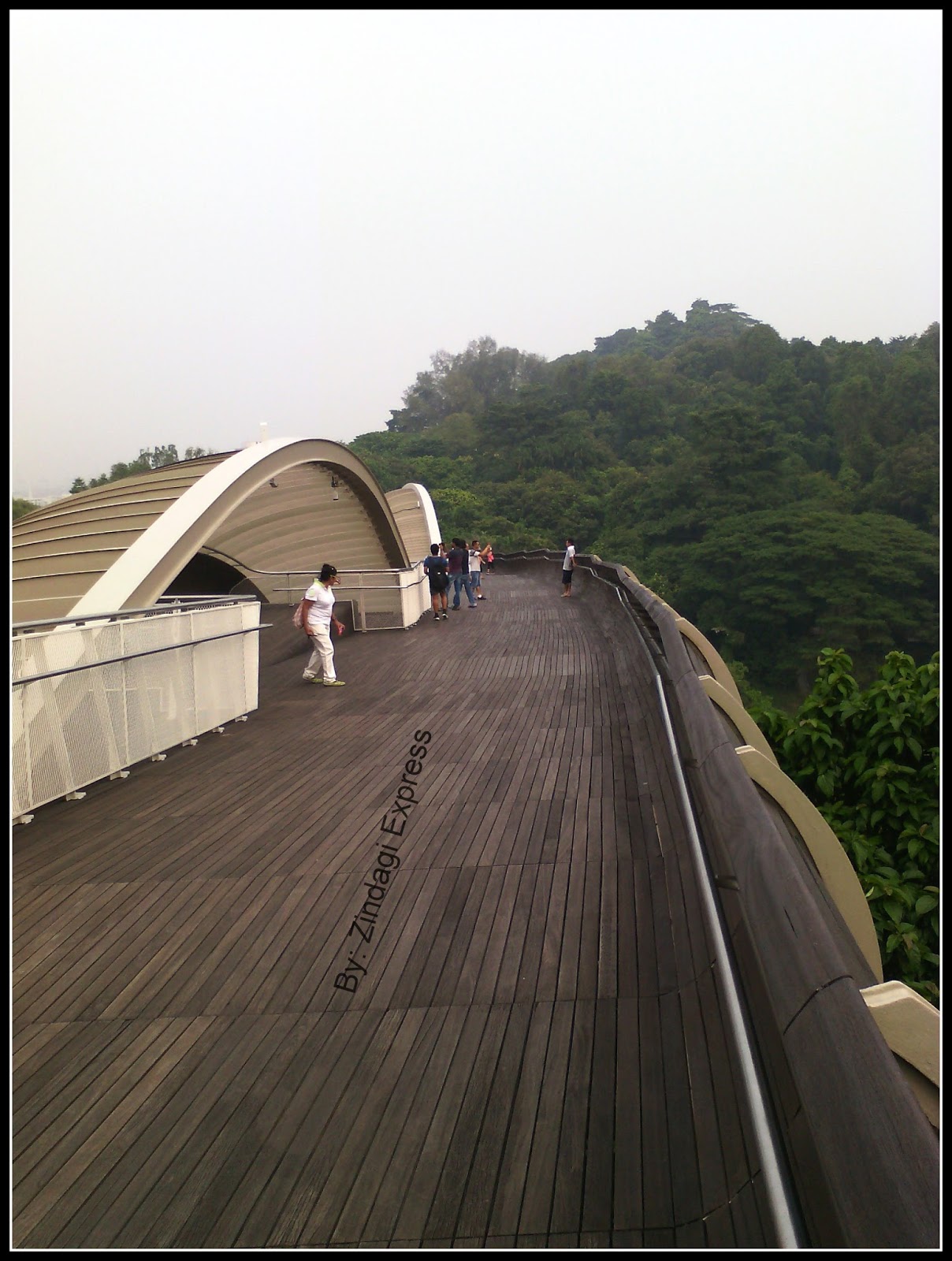
After
capturing some panoramic views and continue my path, I reached Henderson waves,
structure not to be missed.
 |
| Me posing at Henderson Waves |
 |
| Various small tracks of Southern ridges and their distinct identity |


 |
| View of the city from Henderson Bridge |
 Continuing
on my path and saw numerous paths going in different directions with proper
signboards however at 1 or 2 places they were missing so I had to wait until I
saw some joggers to inquire the route to forest walk. It was quite easy.
Continuing
on my path and saw numerous paths going in different directions with proper
signboards however at 1 or 2 places they were missing so I had to wait until I
saw some joggers to inquire the route to forest walk. It was quite easy.
I
was very excited once the Forest walk started. It looks amazing. It consists of
1.3 km track of crisscross metallic structure that offers you an unique
experience of walking through the forest at a height of 3 to 18 meters from
ground. It was descend for me so I didn’t feel tired. This part of the route I
enjoyed most and covered with very easily.


1
point to note that I saw most of the people going in opposite direction and it
looks to me that that path is also quite famous among locals. Then there is
Alexandra Arch that connects to the HortPark but as this point, I took exit and
begin to wait for bus for my Hotel at Orchard Road. Lighting hours for Alexandra Arch
are 7 pm – 12 am daily when LED lights
keep on changing and keep you spellbound.
 |
| Alexandra Arch |
It
is at this location famous B-school SP Jain Institute of management is located
having main branch at Mumbai.
 |
| I took this exit from Alexandra Arch to take Bus from SP Jain School of management. |
Finally,
I can say this trail is not as difficult as MacRitchie trail and offers
numerous entry and exit points. People can directly come by Cab to see the
Henderson waves.
 Finally,
when I completed this track I started dreaming of covering this trail in a
rainy season with carrying umbrella and thought how beautiful it will be.
Thought not the entire track, but Forest walk is pretty much safe in a rainy
season. Also, Forest walk is lighted from 7 pm – 12 am & 5 am – 7 am daily. Seeing this , I
came to know this place is more famous for evening and night time walks as
compared to morning walks.
Finally,
when I completed this track I started dreaming of covering this trail in a
rainy season with carrying umbrella and thought how beautiful it will be.
Thought not the entire track, but Forest walk is pretty much safe in a rainy
season. Also, Forest walk is lighted from 7 pm – 12 am & 5 am – 7 am daily. Seeing this , I
came to know this place is more famous for evening and night time walks as
compared to morning walks.
This place is worth and every
nature lover must visit this to experience bliss especially in a densely
populated urban jungle of Singapore.
Also, Henderson waves and
Alexandra Arch along with the Forest walk were selected for the competition to
seek the best concepts for bridges. Being at such places, one can imagine
cultivating greenery and nature is a culture and if people really want they can
create gardens and nature friendly places anywhere. Shortage of space is not an
excuse for the government to shy away from developing the parks. This is 1
important lesson that every country should learn from Singapore.
For the more
information refer the below site literally having all the details one wants to
refer before beginning his trail: https://www.nparks.gov.sg/
If you like to read about my other blog on MacRitchie trail, refer here
If you like to read about my other blog on MacRitchie trail, refer here
If you like this post, please like my Facebook page.